36°47′57″S 147°13′28″E
Text
The Kiewa River, in north-eastern Victoria, is not especially long, nor is it especially famous. But its sonic environment —— the interplay of water, weather, non-human voices, and the machinery of human intervention —— offers a powerful way to explore how landscapes are shaped, inhabited, and remembered. This project approaches the Kiewa as an acoustic field, a site where ecology, history, and infrastructure intersect in ways both audible and imperceptible.
By working with field recordings, hydrophone data, and site-responsive sound practices, the project examines how listening can serve as a method of environmental attention. It draws on the histories of the Kiewa River —— from its glacial beginnings to its regulated flows —— and the deeper knowledge held in Country by the Dhudhuroa and Waywurru peoples, for whom this river has long been a place of sustenance, travel and connection.
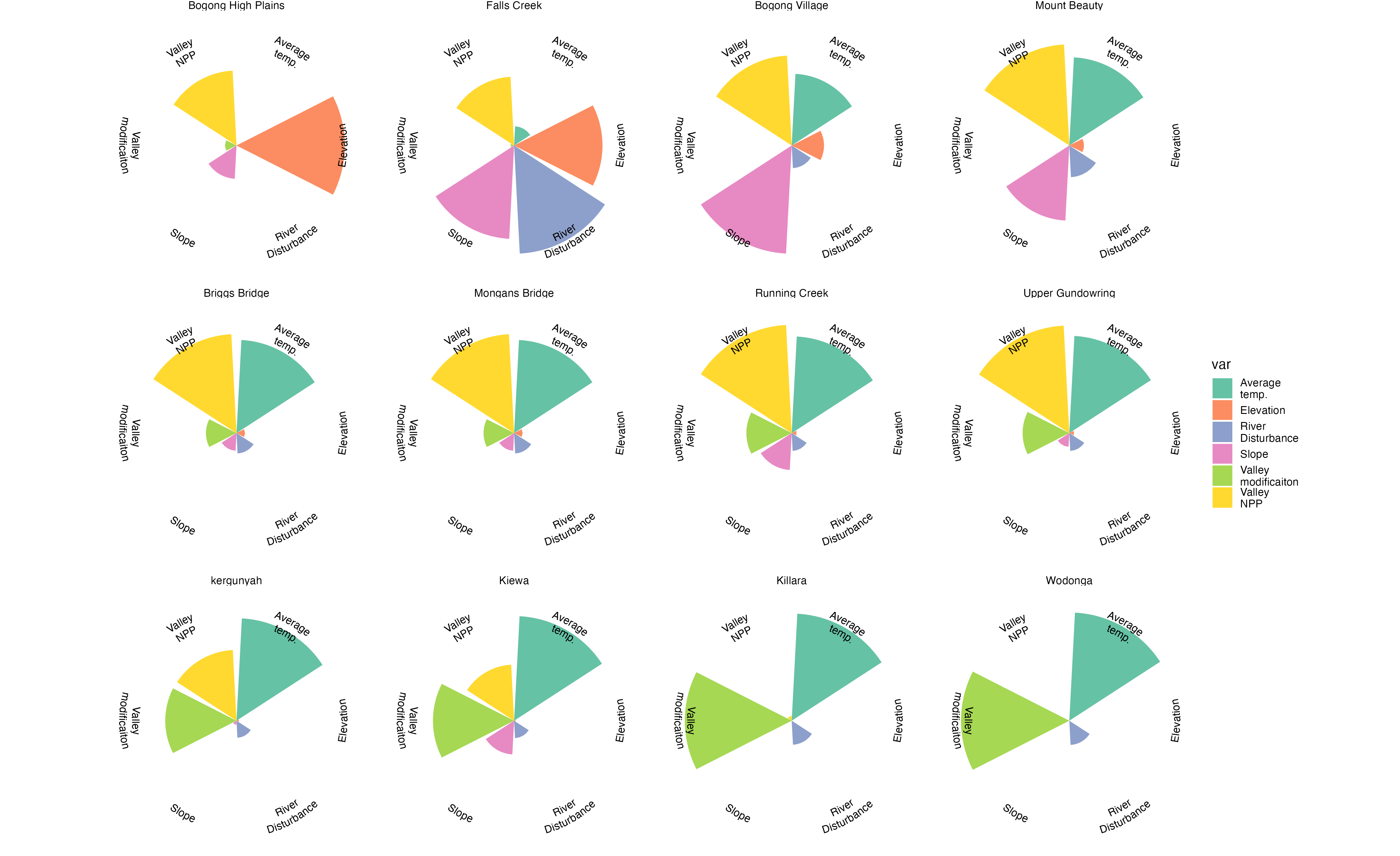
The project’s interactive web interface employs an aleatoric design in which sound and image from different river locations are asynchronously combined. This approach resists fixed or linear representation, instead presenting the Kiewa as a fragmented and interconnected ecological system. By creating unexpected audiovisual relationships, the platform reflects the river’s layered histories, environmental change, and the distributed impacts of human intervention.
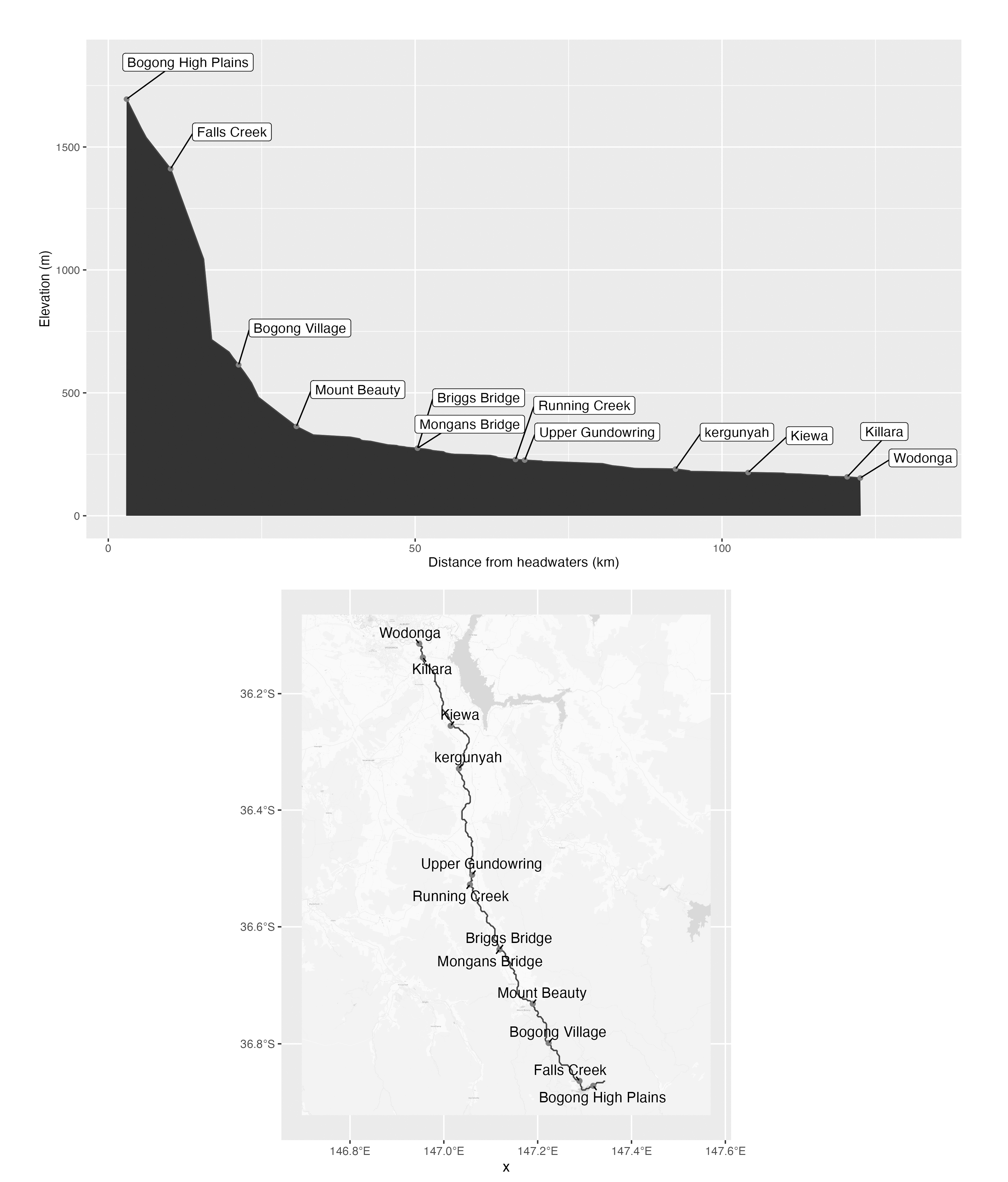
The Kiewa River originates in the Bogong High Plains, part of the Victorian Alps. Its headwaters emerge from snowmelt, springs, and alpine wetlands —— environments shaped by glaciation and seasonal freeze-thaw cycles. These high-country beginnings are marked by a particular clarity of sound: fast-moving, oxygen-rich water rushing over rock and through narrow gullies. At these elevations, the river carries not only water but also the acoustic memory of thawing ice, wind through snowgrass and the distant call of alpine birds.
As the river descends through montane and subalpine forest, it is joined by tributaries including the Pretty Valley and Rocky Valley creeks. Here, the landscape changes: tall mountain ash forests, wetter gullies, and thicker canopy. The flow begins to slow and widen. The East and West branches of the river meet near Mount Beauty —— a site of significant hydrological manipulation —— to form the main Kiewa River. From here, the river travels northward through the Kiewa Valley, past towns like Dederang and Kergunyah, before finally merging with the Murray River near Bandiana, just east of Wodonga.
This physical journey —— from high-altitude source to lowland confluence —— shapes a corresponding acoustic trajectory. Along its course, the river’s soundscape shifts in texture and tone. Fast, fractured turbulence gives way to broader, more sediment-laden flows. Aquatic and terrestrial life changes with elevation: the piercing calls of alpine birds in the upper reaches gradually make way for frogs, reeds, and riverbank insects in the plains. Each bend, barrier, and tributary adds another layer to the river’s sonic profile.
The Kiewa River has been part of Aboriginal life for tens of thousands of years. The Dhudhuroa and Waywurru peoples, Traditional Owners of the region, hold knowledge systems tied to the movement of water, the behaviour of animals, and the cycles of the seasons. The river was —— and remains —— a route of travel, a source of food, and a site of spiritual meaning. Each section of the river carries its own stories, some known and held, others interrupted by colonisation.
In the warmer months, groups moved into the high country to harvest the Bogong moth, a rich and energy-dense food that gathered in large numbers in alpine crevices. These journeys followed river corridors and were guided by deep environmental knowledge. The acoustic cues of the river —— the strength of its flow, the calls of returning birds, the presence or absence of frogs —— were part of a broader system of observation and care.
Colonisation, land clearing, and hydropower development dramatically altered these relationships. The Kiewa Hydroelectric Scheme, constructed in stages between the 1930s and 1960s, diverted major flows, dammed key alpine water sources, and reshaped the river’s natural rhythms. What once pulsed with seasonal variation now flows according to energy demand. The sound of water is often joined by the low hum of turbines, vehicular access, and other anthropogenic noise. The river still flows, but its voice has changed.
This project treats the Kiewa River as a dynamic, living sound environment. Using field recording, hydrophone capture, and on-site listening practices, the work traces how sound reflects ecological change —— and how it can make visible (or audible) forms of disturbance and care that might otherwise go unnoticed.
In the upper reaches, the clean tonal frequencies of meltwater flow are often accompanied by minimal background noise. Further downstream, new textures emerge: the low-frequency rumble of dam outflows, the high-frequency patterns of cicadas, the slow intrusion of distant road traffic. At times, the river disappears entirely from the soundscape, masked by anthropogenic noise or subdued by altered flow regimes.
What’s also heard —— or not heard —— becomes important. The absence of frog calls in areas once rich with amphibians. The sudden quiet of a forest recently logged. The mimicry of a lyrebird imitating chainsaws. These acoustic patterns tell us something about how the environment is responding to historical and contemporary pressures.
To listen to the Kiewa River is to enter into a set of overlapping relationships: with place, with history, with non-human life. It requires slowing down and being present. It asks us to attune ourselves to subtle shifts, to respect silences, and to understand sound not as background, but as evidence.
This project does not aim to restore a “pure” or “original” soundscape —— such a thing is neither possible nor historically accurate. Instead, it offers a way of engaging with a river that has always been changing, and always been listened to. Through sound, we encounter both the ecological resilience of the Kiewa and the complex legacies of human activity. In doing so, the work positions listening as both a method of inquiry and a form of ethics. It is an attempt to trace not only the flow of water, but the ongoing resonances —— ecological, cultural, acoustic —— that shape how we live with rivers today.
The Kiewa River Sound Map
An Introduction to the Acoustic Ecology
of a River System
Text